
Buoyage and Lights
Beacons and Daymarks
It is very common to find navigational marks other than buoys. This is especially true in areas like the Channel Islands and Brittany. In these regions the tides are so fierce and the weather extreme, that buoys are soon swept away.
The solution is to build large towers as beacons. These usually follow the I.A.L.A. convention of lateral and cardinal marks, but other constructions must be expected.
Below are a few examples:
|
An east cardinal beacon at the entrance to L'Aberwrach, in Brittany. |
|
|
A large port hand beacon and light, on the approach to St Malo. |
|
|
A small port hand beacon near to Treguier in Brittany. |
|
|
A small starboard hand beacon and light at the entrance to the River Hamble. |
|
|
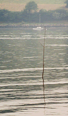
In small rivers and creeks, withies or perches are often used. Their main advantage is that is confined waters they do not move in the wind and tide. They can then be relied upon to provide a good indication of shallow water. They are also cheap, being a branch or tree stuck in to the mud! |
 |
The rule is; be ready for the unexpected. There is little indication on the chart as to the size of a navigational mark.
Daymarks
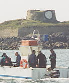
Some times prominent features are used to help the navigator. These will usually be on a prominent hill or headland.
|
A prominent Daymark just east of the entrance to Dartmouth harbour in Devon. |
 |
|
A building painted for use as a leading line in L'Aberwrach in Brittany. |
 |
Sailtrain.co.uk is free to use, but if you feel you would like to contribute to the running and development costs you can donate via Paypal:
Additional Resources:
