
Navigation and Chart work - Fixing the vessel's position
Fixing Position
One of the most important parts of going to sea, especially in coastal waters, is to know where you are at all times. There are several ways to do this.
Observation
The first skill to develop is the ability to look around the vessel, and know to within a small area where you are on the chart just by observation of the features in the area.
The reason I say that, is because one of the result of taking a navigation course is that the student's attention becomes focused on working on the chart and not looking where they are going. It can end up a bit like trying to drive a car, holding a map in front of you and not looking where the road goes! This is exactly what happens in many boats.
You must spend more time, looking around, at the water, weather, other boats, banks, the shore, buoyage and any other features as they pass, than looking at the chart. The information thus gained can then be related to the chart when you next go below. Lots of short visits to the chart table are preferable to sitting looking at it for long periods.
One problem you may well encounter is that you feel seasick when you first navigate. This is because it is a little like reading in a moving car. One way to reduce this risk is to minimise the time spent below; this is facilitated by good preparation.
Position lines
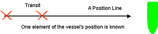
A position line is a line which can be drawn on the chart, which the boat can be said to be on. The standard symbol for a position line is one arrowhead at the end of the line furthest from the object.
With a position line you only know that you are on that line, to find your position you must cross this first line with a second. This gives a Fix.
When you are sailing in an area that you are familiar with and do not need to navigate, you may be able to keep track of where you are, by using a series of single position lines from transits. This will help you know approximately where you are all the time. All you do is plot the first one on the chart then a short while later plot another that is at a different angle to the first, by allowing for the course steered the position of the vessel is often easy to see.
Sources of position lines
There are many sources of position lines, the three most commonly used ones are below.
- Transits, as in the example above, give the most accurate position lines, because there are no compass errors, and they are easy to use.
- Bearings are probably the most commonly used position lines, because
 with a hand bearing compass it is very easy to take several bearings at the same time. A hand bearing compass does take practice to learn to use and may have unknown errors.
 - Depths, especially when taken on contour lines can give a position line. This is not very accurate, but absolute accuracy is not always important, a general idea of where you are, may be enough to indicate that you are in safe water.
Additional Resources: