
Navigation and Chart work - Dead Reckoning and Estimated Positions
Dead reckoning
We have looked at how to find out where you are by plotting position lines to obtain a fix. The biggest disadvantage of doing this is that it only works if there are features that can be used to create position lines. So how do we know where we are when far out to sea or in poor visibility?
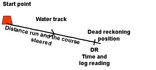
The method we use is to draw lines that represent the movements the vessel has made over the Earth's surface.
If we have a known start point, such as a buoy or a fix, know which direction we have steered the boat and how far we have travelled, we can draw lines to represent these movements on the chart. This gives us our new position.
Of course, dead reckoning does not take into account the tide, so is of limited use in most North European waters.
We have again used the standard notation, the water track is the direction and distance that the vessel travelled through the water, and it has one arrow part way along.
A DR position is marked with a small line crossing the water track, and writing DR next to it. Most people will find it useful to write the time and log reading next to the DR position as this makes plotting the next DR from this point easier, especially if it is done by a navigator on the next watch.
The information for the direction and distance travelled along the water track come from the information recorded in the Ship's Log Book.
Question 1. Chart 3. Variation = 7°W.
Starting at the Safe Water Buoy (45° 40.70'N 006° 13.83'W), a yacht sails for 5.0M on a heading of 304°M. What is its dead reckoning position?
Question 2. Chart 3. Variation = 7°W.
Starting from the Safe Water Buoy (45° 40.70'N 006° 13.83'W), a vessel motors on a heading of 253°M for 8.0M. What is its DR position?
Estimated positions
An estimated position is the best guess that you can make for the boat's movement across the Earth's surface. To start with, the extra information that we need to allow for is the direction of the tide (set) and the distance it has carried the boat(drift).
You begin as for the DR, but at the end of the water track, you draw in the tidal vector. This is the line that represents the direction of the tide and the distance it has carried you. The tidal vector has three arrows, and the EP is indicated by a triangle around the position. An EP should also have the time and log reading of the time it was plotted.
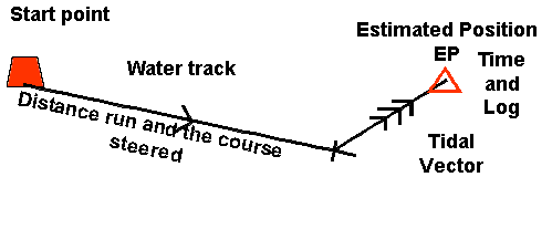
An EP should be plotted every hour when on an open water passage or at every course change in more confined waters. Although normally plotted hourly, an EP can be plotted for any period of time, it is just necessary to ensure that the period of the tide allowed for matches the length of time of that leg of the voyage.
Question 3. Chart 3. Variation = 7°W.
A vessel leaves the West Point Buoy (46° 21.42'N 006° 17.25'W) on a course of 240°M. 1 hour later the log shows that she had travelled 5.2M. If the tide was 180°T at 2.0Kn, what is the E.P?
Ground Track
If we could observe a vessel on a passage from above, the track that it would take would be from the start point directly to the triangle marking the EP. This line is called the Ground Track or Course Over Ground (COG). The Gound Track is normally given in degrees true, as being a measured angle it does not involve the use of the compass.
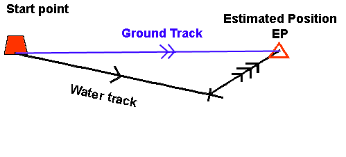
The ground track is not normally drawn in when plotting an EP, but when you are doing navigation exercises you may be asked questions about it.
EPs when beating
If you are sailing to windward it may be possible to plot the water tracks for each leg then plot the whole period of the tide at the end.
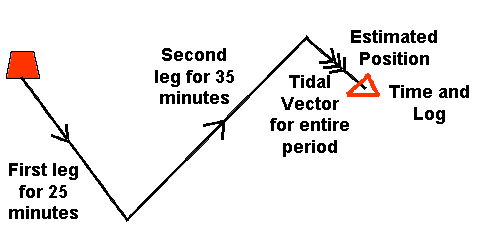
This is especially useful when the different legs are for varying period of time. Rather that finding how far the tide carried the boat in 25 minutes and 35 minutes, all we really need to know is how it affected the vessel over the hour. This also saves plotting two tidal vectors.
Of course if this is done, the Ground Track is not from the start to the final EP. To find the ground track on each leg you would need to plot each section separately.
Question 4. Chart 3. Variation = 7°W.
| Time | Comments | Course | Log | Wind |
| 0900 | At Colville E.Entrance OcR. Light to Starboard of vessel. |
Pilotage | 0.5M | N3 |
| 1000 | EP plotted. | 020°M | 7.0M | N3 |
A. If the tide was 106°T 3.5Kn. What is the EP at 1000?
B. What was the ground track in degrees true?
C. What was the distance made good?
Question 5. Chart 3. Variation = 7°W.
| Time | Comments | Course | Log | Wind |
| 1430 | Bearing from LCW Buoy (46° 02.8'N 005° 57.6'W) 000°T 2.5M. A/C to 050°M |
000°M | 10.6M | SE4 |
| 1530 | EP plotted. | 050°M | 15.8M | SE4 |
If the tide between 1430 and 1530 was 319°T at 1.6Kn. What is the EP at 1530?
Question 6. Chart 4F. Variation = 7°W.
The dot at the centre of the compass rose has been plotted as a waypoint. The bearing to the waypoint is 070°T 1.3M.
Plot the vessel's position.
In the next hour the vessel sails 1.6M in a direction of 034°M, if the tide is 266°T at 0.5Kn, what is the vessel's EP?
Question 7. Chart 3. Variation = 7°W.
| Time | Comments | Course | Log | Wind |
| 1430 | Starting from a position 270°T 1.5M from Stevens Rock (46° 03.4'N 006° 18.8'W). |
060°M | 2.5M | SE4 |
| 1448 | A/c to 306°M | 060°M | 4.5M | SE4 |
| 1530 | EP plotted. | 306°M | 8.7M | SE4 |
If the tide was 012°T at 2.2Kn. What is the EP at 1530?
These next examples include leeway. Before attempting them visit the page covering leeway application.
Question 8. Chart 3. Variation = 7°W.
| Time | Comments | Course | Log | Wind | Leeway |
| 0900 | Starting from Stbd. hand buoy (45° 37.70'N 006° 13.04'W) |
307°M | 12.3M | WSW5 | 5° |
| 1000 | Estimated Position plotted | 307°M | 19.3M | WSW5 | 5° |
If the tide was 230°T 2.5Kn, plot the E.P. at 1000.
Question 9. Chart 3. Variation = 7°W.
| Time | Comments | Course | Log | Wind | Leeway |
| 0900 | Starting from Stbd. hand buoy (45° 37.70'N 006° 13.04'W) |
307°M | 12.3M | WSW5 | 5° |
| 0930 | A/c to 205°M | 307°M | 16.3M | WSW5 | 5° |
| 1000 | Estimated Position plotted | 205°M | 19.3M | WSW5 | 5° |
What were the true water tracks on each leg?
Additional Resources: