

Navigation and Chart work - Latitude and Longitude
Latitude
Positions can be given as a latitude and longitude. On Chart 1, on the north west side of the chart you will find 50°00 north. This line, which forms part of a circle all the way around the World, joins all the points which are 50 degrees north of the Equator (° is the symbol for degrees).
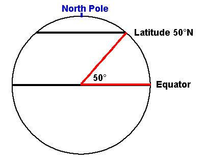
Latitude is the angle measured at the centre of the Earth, between the Equator and where you are. It is expressed either north or south, and varies from 0° to 90°.
Each degree is made up of 60 minutes (').
Moving north from 50° on the chart. You can see divisions for 05' and 10' north.
The first of these would be written as 50° 05' N and the second 50° 10' N
Each of these 05' divisions is made up of 01' divisions. 1' is made up of 60 seconds (''). We do not use seconds of latitude or longitude, as it is far too small a measure for us to draw to.
Each minute is instead divided in to decimals (tenths). On the west side of the chart, there is a power cable (magenta wiggly line) which cuts the side of the chart. This point is 49°50.6'N.
The next power cable south is at a latitude of 49°26.6'N. Because of the scale of this chart, each minute is broken down in to 5 units of 0.2'.
Different charts have different scales. On Chart 2, the minutes are divided in to 0.1' units. The point on the west side of the chart where the sea changes from white to blue (the 20-metre contour) is at a latitude of 50°12.16'N.
On this chart we can be accurate to two decimal places because the spacing of the markings is further apart.
Longitude
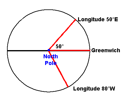
Longitude is the angle at centre of the Earth, between where you are and Greenwich. It can be measured either east or west and varies from 0° to 180°.
On Chart 1, in the north east corner you will find the 5°00'W point. Travelling west the chart changes from green to blue as you cross the river in Plymouth at 5°12.0'W, then back to green at 5°12.3'W.
On Chart 2, there is not a whole number of degrees of longitude, so the meridian (line of longitude) nearest the centre of the chart has the whole longitude written out, 4°35.0'W. Notice that east of this point the next figure is for 4°30.0'W-not 3°30.0'W! This often occurs, if you are not sure of the whole number of degrees on a chart; look at the Southwest or Northeast corner. In very small figures you will find the latitude and longitude of that point, just inside the border.
The latitude and longitude scales are completely different. With your dividers, try measuring 5' of latitude on Chart 2, then compare this to 5' of longitude on the same chart. The latitude is much greater; in fact, the only place where the scales are equal is on the equator.
Measuring Latitude and Longitude
To measure the latitude of a feature, use your dividers to measure
the  distance between the point, and the nearest line of latitude
(horizontal line on the chart), then transfer this distance to the side
of the chart, measuring from the same line of latitude.
distance between the point, and the nearest line of latitude
(horizontal line on the chart), then transfer this distance to the side
of the chart, measuring from the same line of latitude.
On Chart 1. What is the latitude of the small dot in the center of the compass rose in the south west of the chart? Answer.
To find the longitude
of a feature, we do a similar thing, but
instead measure  from a line
of longitude (a
meridian), then
transfer to the top or
bottom of the chart.
from a line
of longitude (a
meridian), then
transfer to the top or
bottom of the chart.
On Chart 1. What is the longitude of the dot in the compass rose in the south west of the chart? Answer.
When you have done this a few times you will find that you become quite fast at the process.
Try finding the latitudes and longitudes of the dots in the center of the other compass roses on Chart 1 and Chart 2.
Plotting positions on charts
To plot a position on a chart you can not use the dividers to find both distances so we need to use the plotter as a straight edge. By drawing a line out from the side of the chart, at the correct latitude we can then use the dividers to measure off the longitude from a meridian, in the reverse of the operation to find the longitude of a point.
When you do this use the cross lines on the plotter against the grids 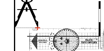 drawn on the chart to ensure you are drawing a line at a right angle to the edge of the chart. Small errors is alignment can produce a large error in the final position.
You could draw a line for both the latitude and longitude but it is more accurate to use the plotter for one and the dividers for the other. Always draw the line that is the shortest distance. On Chart 2, this would often be the line of latitude because of the shape of the chart.
Plot the following positions on Chart 2 and identify the symbol at each point. When you have identified each point accurately draw a small cross at that spot and note the number next to it. You will be able to use them for later exercise.
1. 50°18.55'N 04°28.64'W
2. 50°18.28'N 04°30.30'W
3. 50°20.15'N 04°28.65'W
4. 50°19.30'N 04°26.78'W
Additional Resources: