
Navigation and Chart work - Chart Information
Look at Chart 2. Under the title there is some important information that is explained below.
DEPTH IN METRES
These are metric charts. Most are now, but you will still find some Imperial ones in use. Imperial charts have depths in fathoms and feet (a fathom is 6 feet, about 2 metres). These charts are easily identified, as they are in black and white, not coloured like the metric ones.
Take care with Stanford's charts of the Caribbean, as on some, the depths are metric and others are in imperial units. Because both types look similar, it is easy to miss the change when you move from one chart to the next.
SCALE 1:75 000 at lat 50 ° 30'.
Chart scales vary dependent upon the use they will be put to. A vessel should carry a selection of charts, which cover a variety of scales. This should ensure there are large-scale charts for entering harbour and pilotage, medium scale charts for navigating on and small-scale charts, which cover large geographical area for planning passages.
Depths are in metres and reduced to Chart Datum.
Chart Datum is essentially the level below which the tide never falls, allowing for the movements of the Sun, Earth and Moon.
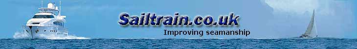
On Admiralty charts, all the blue and white coloured areas are 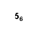 permanently water. The numbers written in these parts are the minimum depths to be found at that point, in metres and decimetres. Normally there will be a greater depth of water as it is unusual for the tide to fall that low. The depth on the right indicates a minimum depth at that point of 5.6m.
These numbers or CHARTED DEPTHS are not the only depth  indication. There are also contour lines on the seabed. These join places of equal depth below chart datum. The depth is written within the contour line.
If you can not see a depth indicated, look at the depths on either side of the line and you should be able to deduce the depth at the contour. It will normally be a multiple of 5 or 10m except the 2m contour on some charts. Find Hurlestone Point on the north east corner of North Coombe Island. Just above the legend "HURLESTONE PT" on the chart there are two depths indicated, 17.2m and 27m, the contour line between them must be the 20m line.
HEIGHTS are in metres. Underlined heights are drying heights above Chart Datum; all other heights are above Mean High Water Springs.
The green areas of the chart are sometimes covered and sometimes 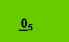 not. In these places there are numbers which are DRYING HEIGHTS. On chart 2, find North Coombe Island, on the north west side there is a bay (Horsesands Bay) where the beach covers and uncovers with a drying height of 0.5m.
Chart Datum is the level from which the height of the tide is measured, when you look in a tide table and the height of high water is given as 4.5m, that is 4.5m above Chart Datum.
Drying heights are heights above Chart Datum, in an area with a drying height of 0.5m, the depth of water would be 0.3m if the height of the tide was 0.8m and the bottom would be 0.2m above the water level if the height  of the tide was 0.3m.
If the height of the tide falls to 0m, the water level would be on the border between the green and blue areas on the chart.
The buff or yellow areas are above Mean High Water Springs and are nearly always uncovered. They may only cover if there is an above average high tide. For most practical purposes we can say that these areas are always land. However in an area of salt marsh all these areas may be covered at the highest tides which can make pilotage quite tricky due to the completely different shape of the land..
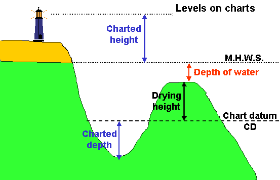
Heights of land feature are called CHARTED HEIGHTS. They are measured above Mean High Water Springs (the average of the highest high tides).
A height above mean high water springs may be indicated by a contour line, by a spot height, that is a number with a dot next to it (On chart 2, find the 30m spot height near the north end of North Coombe Island) or on a feature such as a lighthouse by the height being included in the detail of the light, in this situation "m" indicates metres and "M" indicates miles.
Berry Head light house (Fl(2)15s58m14M) on the south east corner of Tor Bay on chart 2, has a height of 58m above mean high water springs and a nominal range of 14 miles.
Where the feature is too small for the height to be written on it, such as a small rock or islet, the height will be written next to the feature but will be enclosed in brackets. See if you can find ORE STONE in the north east corner of Tor bay on chart 2, this rock stands 32m above mean high water springs.
Positions are referred to Ordinance Survey of Great Britain (1936) Datum (OS 36).
When the curves of the Earth's surface are converted to a flat sheet, map makers have a model of the shape of the world, which affects the way the chart appears. Different organisations use different models for the shape of the Earth.
In the past this was not important, as the differences were very small compared to the level of accuracy of navigation. However, Global Position System (GPS) navigators give a position to 3 decimal places, around Britain this is a theoretical accuracy of about 2 metres. This is obviously ridiculously accurate as the charts were not surveyed to this level of accuracy, and in practice the system should probably only be relied on for an accuracy of 100 metres. Certainly once you are this close to hazards you need to be looking for them rather than relying on the electronics!
Because GPS uses a datum called WGS 84 (World Geodetic System 1984) for a model of the world, where is a built in error when converting GPS positions to positions on a chart using OS 36 datum.
Further down on the chart, there is a special warning about the use of satellite derived positions on this chart. As you can see it is a very small error in this part of the world. However, you should always check to see which datum has been used, and what the error is, because in some places the error may be significant.
To be strictly accurate, GPS positions should be corrected by the amounts given. To avoid this you may find in the set up menu of your GPS receiver that you can change the datum to match that of the chart you are using.
If you look on Chart 1, the Datum used is European Datum 1950, which is different again; there are many datums in use.
Many new charts are being printed which use WGS 84 as their datum, this means they will match positions given on your GPS navigator, so in future this will be less of a problem. There are thousands of charts to change, so this will take some time!
Navigation marks: IALA Maritime Buoyage System - Region A (Red to port).
This tells you the buoyage system in use in the area covered by the chart. There are two systems, A and B, system B buoyage mainly being used in America. Go to the section on buoyage to find out more.
Additional Resources: