

The functions on a GPS receiver
GPS receivers have several functions that a good navigator will practice using until they are second nature.
Position
The vessel's position is displayed normally at the press of one button. It will be given in latitude and longitude to three decimal places.
Everyone on board should know how to obtain the vessel's position, this should be included in the safety brief. Anyone should be able to send a distress message over the radio and knowing how to find the vessel's position is an integral part of this.
COG
The receiver will display the Course Over the Ground (COG), this is the actual course being achieved after tide and leeway is allowed for. This should be consulted to help project where the vessel will be at future points of time. Obviously, as the tide changes predictions of future positions will need to be adjusted.
SOG
The vessel's true Speed Over the Ground (SOG) is also indicated, this can be invaluable for assessing what the tidal stream is really doing.
Bearing and distance to a waypoint
If a waypoint (a point the vessel will pass through) has been entered, the set can display the bearing and distance to this waypoint. This function can be very useful but can also be misleading.
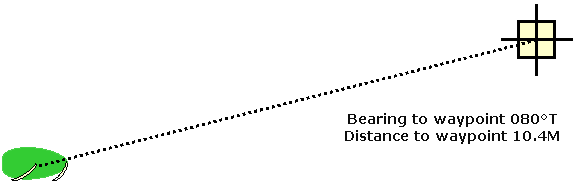
In non-tidal conditions the bearing to the waypoint will be the course to steer but when there is a cross tide the boat will be swept off course if you follow the bearing to waypoint. You will arrive eventually but by a longer route than is necessary.
The waypoint alarm can be set to activate when you reach a preset distance from the next waypoint.
Time to go (TTG)
The Time To Go to reach the waypoint can be displayed. This will probably change a lot in a sailing boat as the vessel's speed changes, however one useful trick can be to use it to help trim the sails. Small changes in sail trim may not show up on the vessels log (knot meter) but if the boat is going faster the TTG will decrease.
Cross Track Error (XTE)
Cross track error is the distance the vessel is to one side of the straight line between two waypoints. Over short distances it can help to keep XTE at a small figure, over longer distances such as a cross Channel trip from the Solent to Cherbourg the XTE should be allowed to increase then decrease as the vessel is first swept one way by the tide then back again.
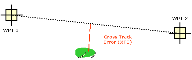
On a cross Channel trip the figure for XTE may be as high as 15M. If XTE is kept to a minimum in this situation the vessel would sail further than necessary and take several hours more to complete the voyage.
Routes
Most GPS receivers will allow you to enter a series of waypoints and link them up to create a route that can be stored for a future repeat trip.
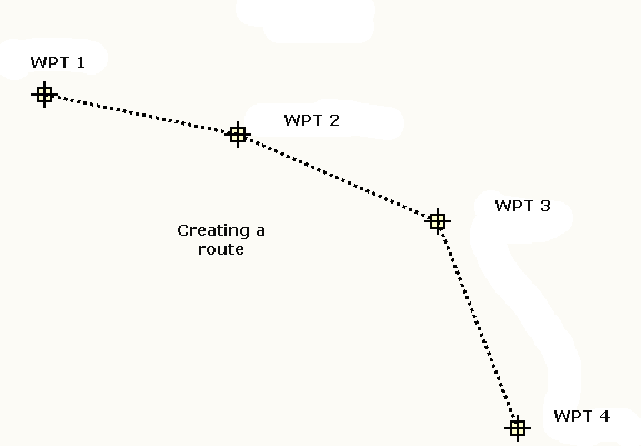
As the vessel travels along each leg of the route the bearing and distance to the next waypoint are displayed and an alarm will set off at a pre-determined distance from each waypoint. The receiver will then switch to following the next waypoint until the voyage is completed.
Anchor alarm
The anchor alarm can be set to any distance. If the vessel moves outside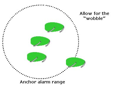 this limit the alarm activates. The limit set should allow for any expected tidal or wind changes plus allowance must be made for the slight "wobble" in the indicated position.
This alarm can give you some peace of mind when at anchor overnight and its use should be automatic when you are anchoring for any length of time.
Man overboard alarm
This is another control that everyone must know how to operate. On most sets a button marked MOB is held down for about 3 seconds. This then enters the vessel's position as waypoint 0, the set then tracks the bearing and distance back to this point, and will also display the vessel's course and speed.
If someone falls overboard this function should be operated immediately, if 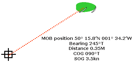 you lose sight of the person, the GPS receiver will give you a good idea of where to start a search. In tidal conditions allowance must be made for the tidal drift, the set will indicate the point where they fell in, not where they are later on. If necessary the position of waypoint 0 should be given to the rescue authorities to help with the search. Rescue aircraft are normally fitted with heat seeking equipment that can detect a person in the water fairly easily, if they know where to start the search.
GPS and Sat Nav Store
Sailtrain.co.uk is free to use, but if you feel you would like to contribute to the running and development costs you can donate via Paypal:
Additional Resources:
