
Clearing lines from GPS.
There are a variety of techniques that can be used with GPS to keep clear of hazards.
Danger range
If a waypoint is placed on a hazard and the alarm range set to a suitable distance this can help avoid a danger such as an isolated rock or wreck.
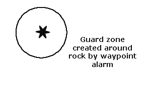 If you have a copy of the RYA Training Chart 2 there is an example of a good place to use this technique. Find the rock Pierre au Vraic about 2.5M SW of Alderney.
This rock is very easy to hit as the tides sweep through this channel at high speeds.
If a waypoint is placed on the rock and the alarm set to a suitable distance for the current conditions you should have plenty of warning if you are approaching too close.
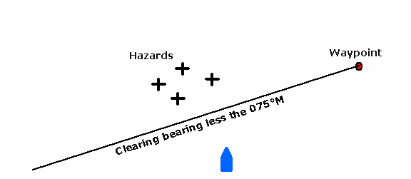
Clearing line from a waypoint
A clearing line can be created from any waypoint, the benefit of doing so with a waypoint rather than a visual bearing to a mark, is that the waypoint can be positioned anywhere that gives you a convenient clearing line.
Clearing line from XTE
If the ground track is plotted on a chart then the distance to the nearest dangers on either side are measured, it is possible to use the Cross Track Error (XTE) function keep clear of the hazards.
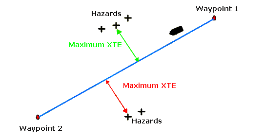
As soon as the XTE approached the limits you have decided upon the vessel should be turned back towards the ground track between the two waypoints.
On RYA Training Chart 2 a good example of this occurs if you plot a track from WPT1 49°40.0'N 005°26.4'W to WPT2 49°30.0'N 005°38.5W, this is through the channel between Herm and Sark with areas of rock on either side. Depending upon the conditions the clearing XTE is about 0.6M. If this was calculated beforehand, it would not be too difficult to safely beat against the wind through this channel.
If a conventional approach of plotting fixes to maintain a safe position was used instead it would be very difficult to achieve in the time available. This is especially so when you consider that the tide could be running at between 4 and 5 knots through the channel.
Sailing upwind
A useful idea is to use the bearing to waypoint function to limit the lengths of tacks when beating to windward in open water.
A waypoint is placed directly upwind of the start point, two lines are then drawn out from this waypoint to form the limits that you do not want to pass. Each time the bearing to waypoint indicates you are at the limit the boat is tacked.
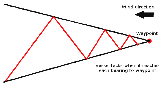
This avoids the situation where you are too far off to one side if the wind shifts direction later in the passage.
If the passage is going to be a long one, another step can be added. Place a starting waypoint, then the one at the destination, draw lines on the chart parallel to the direct line between these two waypoints. These lines should be at the limit you want to set to either side of the ground track.
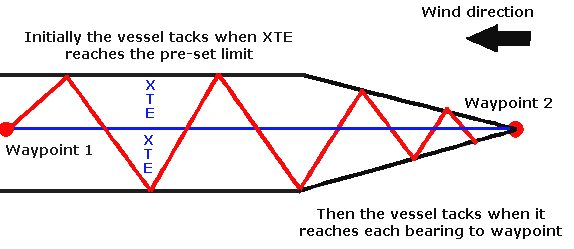
Use the XTE to tell you when you have reached these limits then tack back, this will save you sailing a long way one one tack only to have the wind shift and catch you on the wrong side.
GPS and Sat Nav Store
Sailtrain.co.uk is free to use, but if you feel you would like to contribute to the running and development costs you can donate via Paypal:
Additional Resources:
